


Road Watch Driving Survey
Road Watch has developed a new data collection method - a systematic driving survey where participants are assigned a section of highway to record wildlife observations. This new data collection method will complement the Road Watch data collected through the mapping tool or phone in hotline. The driving survey was developed for two reasons:
- Road Watch participants request to make data collection easier and more efficient for regular users whom drive the road daily and collect a lot of observations.
- To assess the ability of Road Watch data to identify spatial and temporal movement patterns we developed a student project to compare Road Watch data to a one year systematic dataset. A graduate student (Kylie Paul) developed a systematic methodology, collected one year of data with assistnace from a field technician (Rob Schaufele) and compared the results to Road Watch data collected by citizens. Although spatially the data was similar, there were some concerns with the temporal (seasonal and time of day) representation of Road Watch data. A systematic survey (where the rate of sampling effort is recorded) was suggest to improve the accuracy and uses of the data.
Why is systematic data collection important?
Current data collection methods for Road Watch are based on opportunistic observations where a participant's records wildlife sighting along Highway 3 through a mapping tool or call in hotline. Therefore participants are not restricted to a regular route (they are not assigned to sections of the highway) nor do they record when they do not see wildlife. One of the concerns with this type of data collection is data fragmentation. We have no way of knowing if all sections of the highway are being observed consistently through out the year. It is likely that we may have areas along Highway 3 that are over or under represented due to observation rate inconsistencies. Also we can not determine the rate of movement across Highway 3 because we do not record when participants have not seen wildlife along Highway 3. A systematic survey ensures the entire Highway 3 study area is accounted for by assigning participants to sections they regularly drive. This section is treated like a transect, where a participants records the start and end time and all wildlife observations along transect. Therefore even when wildlife are not observed the transect is recorded, enabling us to determine the rate of movement for each species. Additionally we can ensure that the entire length of the highway is accounted for, reducing data fragmentation concerns.
Who should participate in the driving survey?
This data collection method is designed for individuals who frequently drive Highway 3 on a regular route and have an interest in wildlife. Participants are assigned a section of highway (transect) based on current route they regularly drive and are requested to drive the section at least twice a week, ideally at different times of the day (think of four quarters- dawn, day, dusk, night). Using the Otto Wildlife Companion participant records the start of transect, any observations along the way and the end of transect all through selecting the appropriate buttons on the Otto.
What is the Otto Log Wildlife Companion?
The Otto Wildlife Companion provides users with the ability to mark the locations where specific wildlife species are observed along a highway. The locations are stored on the Otto device and the data can be downloaded onto a computer.
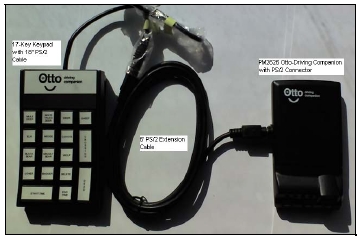
Figure 1: Picture of the Otto driving companion including GPS unit, cables and keypad.
The locations are stored on the Otto device and the data can be downloaded onto a computer. The Otto Wildlife Companion was customized for the Road Watch program to include:
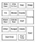
- 11 species identification options (white tailed deer, mule deer, deer, sheep, elk moose, coyote, Black bear Grizzly bear, wolf, badger),
- Other button-to report other species not on keypad
- Crossing button- only used when animal crosses the highway
- Dead button- only used when observed animal is dead along the highway
- Delete button- removed last record entered
- Start transect and end transect
Wildlife Driving Survey methods and Protocols
At a Road Watch participants meeting in February 2008, the following methods and data collection protocols were developed:
Step 1: Decide on the specific section of Highway 3 you regularly drive and would like to take responsibility for. This is your designated transect. Please ensure Rob is aware of the section of highway you plan to drive.
Step 2: Become familiar with the Otto driving companion, see figure A. The Otto can be used for 2 purposes:
- Systematic Transects:
- Decide you are doing a transect prior to entering your specified section.
- Turn your Otto on before the start of transect (a solid green light indicated GPS is ready).
- Select start transect at the beginning of your section and end transects at the end of your section. This will enable us to know when you drove a transect and did not see wildlife, important information for understanding the rate of wildlife movement across Highway 3.
- Try to drive your transect during different time periods (dusk, night, dawn, day)
- Opportunist observations:
- If you are not undertaking a transect you can still use the Otto Driving Companion for wildlife sighting- these observations will be separated from the systematic survey and entered into the Road Watch database.
Step 3: There are two options for downloading your data from the Otto driving companion. 1. arrange a meeting with Tracy (403-220-8968) so he can download the data or; 2. download the software from the link below (resources for driving survey) and email the spreadsheet to the Miistakis Institute. If you choose to use the software please review the instructions in the user manual and remember to select the merge options (dead wildlife and crossing wildlife) when processing.
Data Collection Protocols
- Only record wildlife observations within 50m of Highway 3
- Record the observation with Otto when parallel to species.
- Record herds as one observation, as close to the middle of the heard as possible.
- Always record the species first, if the animal is adjacent and alive you are done.
- If the animal(s) is/are crossing record species first then press the crossing button.
- If the animal is dead record the species first and then press the dead button.
- If the animal is dead you do not need to select the crossing button.
- If you make a mistake press the delete button within 60 seconds and the last record is deleted.
- Other is for species not represented on the keypad, as carnivore sightings are rare please report to Rob the species you record as other.
- Please note there is a deer button, as we recognize that identification can be difficult sometimes while driving down the highway.
How is this data integrated into Road Watch?
The data from the systematic driving survey will be analyzed as another dataset and when appropriate will also be integrated into the Road Watch data. For example the datasets will complement each other on where species are moving across Highway 3. However the systematic dataset will enable Road Watch to address other questions about wildlife movement such as rates of movement and temporal (seasonal) variations when addressing mitigation options. Each dataset complements the other and has the potential to provide additional insights when combined.
Resources for driving survey
- Driving Survey Protocols (One pager)
- Otto Wildlife Companion Manual
- Otto Wildlife Companion Downloader Application